
- sclhdf.nc ©
[..] La fonction [scl] fscan_ncscl
Code
int fscan_nc_xpl(){
scltracefa(§, ƒ, ∅);
scltracefc("scl-%s (%s) : %s\n", sclver(), sclsec(), temps_char(0));
scltracefc(" < netcdf-%s\n\n", sclver_nc());
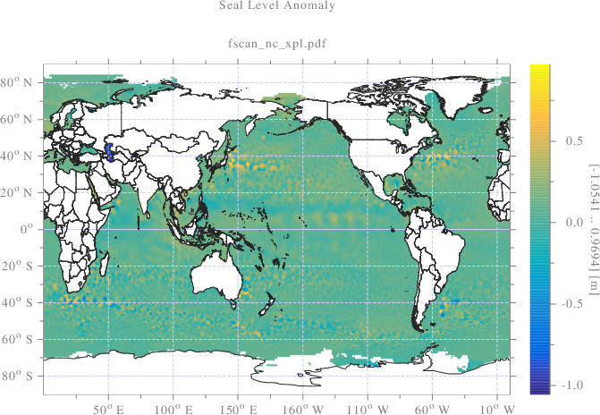
std::string ncfilename = "dt_global_allsat_phy_l4_20161130_20170530.nc";
std::string ncfilepath = "./don/netcdf/" + ncfilename;
finfo_nc(ncfilepath.c_str());
//---------------------------------------------------------------------
//[>INPUT SURFACE]
//---------------------------------------------------------------------
size_t sot; int dimn;
void **nc = fscan_nc(ncfilepath.c_str(), "sla", &sot, &dimn);
int *crdn=(int*)nc[0], latn=crdn[1], lonn=crdn[2], loni, lati;
scltracefc("lonn=%d, latn=%d\n", lonn, latn);
int ***sla = (int***)nc[1]; //[timn=1][latn=720][lonn=1440]
int csla;
double **sla_m = newmat<double>(lonn, latn);
int **slac = newmat<int>(lonn, latn, 1);
for(loni=0;loni<lonn;loni++){
for(lati=0;lati<latn;lati++){
csla = sla[0][lati][loni];
// Test de la valeur de remplissage '_FillValue'
if(csla==-2147483647){ slac[loni][lati]=0; }
// Mise a l'echelle 'scale_factor'
sla_m[loni][lati] = (double)csla*0.000100;
}
}
// Longitude [deg]
nc = fscan_nc(ncfilepath.c_str(), "longitude", &sot, &dimn);
float *lon=(float*)nc[1]; double *lon_deg=new double[lonn];
for(loni=0;loni<lonn;loni++){ lon_deg[loni]=(double)lon[loni]; }
// Latitude [deg]
nc = fscan_nc(ncfilepath.c_str(), "latitude", &sot, &dimn);
float *lat=(float*)nc[1]; double *lat_deg=new double[latn];
for(lati=0;lati<latn;lati++){ lat_deg[lati]=(double)lat[lati]; }
scl::string_c imgname=scl::string_c(ƒ)+".pdf",
imgpath="./srt/"+imgname;
grafmat_dis(imgpath.c_str(), lonn, latn, sla_m, "instatus", slac,
"x", lon_deg, "y", lat_deg, "geographic", "flat",
"colormap", "paruline", "subtitlex", imgname.c_str(),
"zlabel", "[<zrange>] [m]", "title", "Seal Level Anomaly",
"linespeca", "-a", ∅);
#ifndef NON_SHQ_SCL
tabx_t slax;
slax.sot = sizeof(int);
slax.dimn = 2;
slax.crdn = new int[2];
slax.crdn[0]=lonn; slax.crdn[1]=latn;
slax.crde = new int[2];
slax.crde[0]=lonn; slax.crde[1]=latn;
slax.tabx = (void*)slac;
std::string jsoname=std::string(ƒ)+".json",
jsonpath="./srt/"+jsoname;
shq::beginDrawing(/*jsonpath*/); // <Initializes the  "connection"
shq::newFigure("fscan_nc"); // <Creates a new figure;
shq::Params prms = shq::Params("colormap","paruline");
prms["instatus"] = slax;
shq::drawSurface(lonn, latn, sla_m, 0, 0, 1, 1, prms);
shq::axisAuto();
shq::axisEqual("fscan_nc");
/*shq::setFigureProperties("drawline_shq",
shaqParams("x",0,"y",220,"width",450,"height",100));*/
std::vector<std::string> labels;
labels.push_back("[dim-1]"); labels.push_back("[dim-2]"); labels.push_back("[dim-3]");
shq::axisLabels(labels);
shq::saveImage("./srt/fscan_nc.svg");
shq::endDrawing(); // <Closes the "connection"
#endif
//---------------------------------------------------------------------
//[<INPUT SURFACE]
//---------------------------------------------------------------------
//---------------------------------------------------------------------
//[>PROJECTION]
//---------------------------------------------------------------------
double stlona_deg=min<double>(lonn, lon_deg),
stlone_deg=max<double>(lonn, lon_deg);
double stlata_deg=min<double>(latn, lat_deg),
stlate_deg=max<double>(latn, lat_deg);
// Global position number
int stn = lonn*latn;
double *stlonrad = new double[stn], *stlatrad = new double[stn];
maillkar(lonn, stlona_deg, stlone_deg,
latn, stlata_deg, stlate_deg, 1, stlonrad, stlatrad);
deg_rad(stn, stlonrad, stlonrad); deg_rad(stn, stlatrad, stlatrad);
double *stxgdho = new double[stn], *stygdho = new double[stn];
int *stregion = new int[stn];
lls_gdho(stn, stlonrad, stlatrad, stxgdho, stygdho, stregion);
//---------------------------------------------------------------------
//[<PROJECTION]
//---------------------------------------------------------------------
//---------------------------------------------------------------------
//[>VIEW GRID]
//---------------------------------------------------------------------
double dstn = (double)stn;
double stxa_gdho = min<double>(stn, stxgdho);
double stxe_gdho = max<double>(stn, stxgdho);
double stya_gdho = min<double>(stn, stygdho);
double stye_gdho = max<double>(stn, stygdho);
// Projection point surface
double stareagdho = (stxe_gdho-stxa_gdho)*(stye_gdho-stya_gdho);
// View projection x point number
int xn_gdho = (int)(√(dstn)*(stxe_gdho-stxa_gdho)/√(stareagdho));
// View projection y point number
int yn_gdho = (int)(√(dstn)*(stye_gdho-stya_gdho)/√(stareagdho));
scltracefc("xgdhon=%d, ygdhon=%d\n", xn_gdho, yn_gdho);
int gdhon = xn_gdho*yn_gdho, gdhoi;
double *vwx_gdho=new double[gdhon], *vwy_gdho=new double[gdhon];
double *vwz_gdho=new double[gdhon];
maillkar(xn_gdho, stxa_gdho, stxe_gdho,
yn_gdho, stya_gdho, stye_gdho, 1, vwx_gdho, vwy_gdho);
scltracefc("stxa_gdho=%lf, stxe_gdho=%lf\n", stxa_gdho, stxe_gdho);
scltracefc("stya_gdho=%lf, stye_gdho=%lf\n", stya_gdho, stye_gdho);
double *vwlon=new double[gdhon], *vwlat=new double[gdhon];
int *vwin_gdho=new int[gdhon], *vwregion=new int[gdhon];
// Inverse projection
gdho_lls(gdhon, vwx_gdho, vwy_gdho, vwlon, vwlat, vwregion);
rad_deg(gdhon, vwlon, vwlon); rad_deg(gdhon, vwlat, vwlat);
// Translation pour interpolation longitude dans 0-360
for (gdhoi=0;gdhoi<gdhon;gdhoi++){
if (vwlon[gdhoi]<0){ vwlon[gdhoi]+=360; }
}
gdhoi=0;
scltracefc("vwlon[%d]=%lf, vwlat[%d]=%lf, vwregion[%d]=%d\n",
gdhoi, vwlon[gdhoi], gdhoi, vwlat[gdhoi],
gdhoi, vwregion[gdhoi]); //🔬
interpmat(lonn, latn, sla_m, slac,
stlona_deg, stlone_deg, stlata_deg, stlate_deg,
gdhon, vwlon, vwlat, vwz_gdho, ∅, ∅, vwin_gdho);
// inverse projection instatus is added to interpolation instatus
for (gdhoi=0;gdhoi<gdhon;gdhoi++){
if (vwregion[gdhoi]<=0){ vwin_gdho[gdhoi]=0; }
}
double **vwz = tab_mat<double>(xn_gdho, yn_gdho, vwz_gdho, 1);
int **vwin = tab_mat<int>(xn_gdho, yn_gdho, vwin_gdho, 1);
double *vwx = newtablin(xn_gdho, stxa_gdho, stxe_gdho);
double *vwy = newtablin(yn_gdho, stya_gdho, stye_gdho);
//---------------------------------------------------------------------
//[<VIEW GRID]
//---------------------------------------------------------------------
//---------------------------------------------------------------------
//[>PLOT]
//---------------------------------------------------------------------
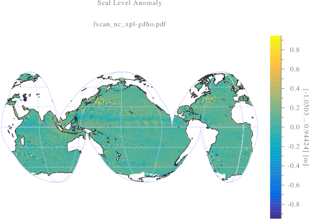
imgname.clear(); imgname = scl::string_c(ƒ) + "-gdho.pdf";
imgpath.clear(); imgpath = "./srt/" + imgname;
double cd=0; int regj;
double vuxa = 20/180*π+scleps();
lls_gdho(1, &vuxa, &cd, &vuxa, &cd, ®j);
double vuxe=-vuxa, vuxd=(vuxe-vuxa)/2*0.01;
vuxa-=vuxd; vuxe+=vuxd;
grafmat_dis(imgpath.c_str(), xn_gdho, yn_gdho, vwz,
"instatus", vwin, "x", vwx, "y", vwy,
"subtitlex", imgname.c_str(),
"geographic", "gdho", "colormap", "paruline",
"axis", "equal", "axis", "off",
"zlabel", "[<zrange>] [m]", "title", "Seal Level Anomaly",
"azmin", -0.944241, "axmin", vuxa, "axmax", vuxe,
"linespeca", "-a", ∅);
#ifndef NON_SHQ_SCL
tabx_t vwix;
vwix.sot = sizeof(int);
vwix.dimn = 2;
vwix.crdn = new int[2];
vwix.crdn[0]=xn_gdho; vwix.crdn[1]=yn_gdho;
vwix.crde = new int[2];
vwix.crde[0]=xn_gdho; vwix.crde[1]=yn_gdho;
vwix.tabx = (void*)vwin;
shq::beginDrawing(/*jsonpath*/); // <Initializes the "connection"
shq::newFigure("fscan_nc-gdho"); // <Creates a new figure;
shq::Params prmg = shq::Params("colormap","paruline");
prmg["instatus"] = vwix;
shq::drawSurface(xn_gdho, yn_gdho, vwz, 0, 0, 1, 1, prmg);
shq::axisAuto();
shq::axisEqual("fscan_nc-gdho");
/*shq::setFigureProperties("drawline_shq",
shaqParams("x",0,"y",220,"width",450,"height",100));*/
/*std::vector<std::string> labels;
labels.push_back("[dim-1]"); labels.push_back("[dim-2]"); labels.push_back("[dim-3]");*/
shq::axisLabels(labels);
shq::saveImage("./srt/fscan_nc-gdho.svg");
shq::endDrawing(); // <Closes the "connection"
#endif
//---------------------------------------------------------------------
//[<PLOT]
//---------------------------------------------------------------------
//---------------------------------------------------------------------
//[>LIBERE MEMOIRE]
//---------------------------------------------------------------------
delete[] lon_deg; lon_deg=∅; delete[] lat_deg; lat_deg=∅;
deletemat<double>(lonn, &sla_m);
delete[] stlonrad; stlonrad=∅; delete[] stlatrad; stlatrad=∅;
delete[] stxgdho; stxgdho=∅; delete[] stygdho; stygdho=∅;
delete[] vwx_gdho; vwx_gdho=∅; delete[] vwy_gdho; vwy_gdho=∅;
delete[] vwz_gdho; vwz_gdho=∅; delete[] vwlon; vwlon=∅;
delete[] vwlat; vwlat=∅; delete[] vwregion; vwregion=∅;
delete[] vwin_gdho; vwin_gdho=∅;
deletemat<double>(xn_gdho, &vwz); deletemat<int>(xn_gdho, &vwin);
delete[] vwx; vwx=∅; delete[] vwy; vwy=∅;
imgname.clear(); imgpath.clear();
//---------------------------------------------------------------------
//[<LIBERE MEMOIRE]
//---------------------------------------------------------------------
scltracefe(§, ƒ, ∅);
return 0;
}
/* ƒ décorée par
"connection"
shq::newFigure("fscan_nc"); // <Creates a new figure;
shq::Params prms = shq::Params("colormap","paruline");
prms["instatus"] = slax;
shq::drawSurface(lonn, latn, sla_m, 0, 0, 1, 1, prms);
shq::axisAuto();
shq::axisEqual("fscan_nc");
/*shq::setFigureProperties("drawline_shq",
shaqParams("x",0,"y",220,"width",450,"height",100));*/
std::vector<std::string> labels;
labels.push_back("[dim-1]"); labels.push_back("[dim-2]"); labels.push_back("[dim-3]");
shq::axisLabels(labels);
shq::saveImage("./srt/fscan_nc.svg");
shq::endDrawing(); // <Closes the "connection"
#endif
//---------------------------------------------------------------------
//[<INPUT SURFACE]
//---------------------------------------------------------------------
//---------------------------------------------------------------------
//[>PROJECTION]
//---------------------------------------------------------------------
double stlona_deg=min<double>(lonn, lon_deg),
stlone_deg=max<double>(lonn, lon_deg);
double stlata_deg=min<double>(latn, lat_deg),
stlate_deg=max<double>(latn, lat_deg);
// Global position number
int stn = lonn*latn;
double *stlonrad = new double[stn], *stlatrad = new double[stn];
maillkar(lonn, stlona_deg, stlone_deg,
latn, stlata_deg, stlate_deg, 1, stlonrad, stlatrad);
deg_rad(stn, stlonrad, stlonrad); deg_rad(stn, stlatrad, stlatrad);
double *stxgdho = new double[stn], *stygdho = new double[stn];
int *stregion = new int[stn];
lls_gdho(stn, stlonrad, stlatrad, stxgdho, stygdho, stregion);
//---------------------------------------------------------------------
//[<PROJECTION]
//---------------------------------------------------------------------
//---------------------------------------------------------------------
//[>VIEW GRID]
//---------------------------------------------------------------------
double dstn = (double)stn;
double stxa_gdho = min<double>(stn, stxgdho);
double stxe_gdho = max<double>(stn, stxgdho);
double stya_gdho = min<double>(stn, stygdho);
double stye_gdho = max<double>(stn, stygdho);
// Projection point surface
double stareagdho = (stxe_gdho-stxa_gdho)*(stye_gdho-stya_gdho);
// View projection x point number
int xn_gdho = (int)(√(dstn)*(stxe_gdho-stxa_gdho)/√(stareagdho));
// View projection y point number
int yn_gdho = (int)(√(dstn)*(stye_gdho-stya_gdho)/√(stareagdho));
scltracefc("xgdhon=%d, ygdhon=%d\n", xn_gdho, yn_gdho);
int gdhon = xn_gdho*yn_gdho, gdhoi;
double *vwx_gdho=new double[gdhon], *vwy_gdho=new double[gdhon];
double *vwz_gdho=new double[gdhon];
maillkar(xn_gdho, stxa_gdho, stxe_gdho,
yn_gdho, stya_gdho, stye_gdho, 1, vwx_gdho, vwy_gdho);
scltracefc("stxa_gdho=%lf, stxe_gdho=%lf\n", stxa_gdho, stxe_gdho);
scltracefc("stya_gdho=%lf, stye_gdho=%lf\n", stya_gdho, stye_gdho);
double *vwlon=new double[gdhon], *vwlat=new double[gdhon];
int *vwin_gdho=new int[gdhon], *vwregion=new int[gdhon];
// Inverse projection
gdho_lls(gdhon, vwx_gdho, vwy_gdho, vwlon, vwlat, vwregion);
rad_deg(gdhon, vwlon, vwlon); rad_deg(gdhon, vwlat, vwlat);
// Translation pour interpolation longitude dans 0-360
for (gdhoi=0;gdhoi<gdhon;gdhoi++){
if (vwlon[gdhoi]<0){ vwlon[gdhoi]+=360; }
}
gdhoi=0;
scltracefc("vwlon[%d]=%lf, vwlat[%d]=%lf, vwregion[%d]=%d\n",
gdhoi, vwlon[gdhoi], gdhoi, vwlat[gdhoi],
gdhoi, vwregion[gdhoi]); //🔬
interpmat(lonn, latn, sla_m, slac,
stlona_deg, stlone_deg, stlata_deg, stlate_deg,
gdhon, vwlon, vwlat, vwz_gdho, ∅, ∅, vwin_gdho);
// inverse projection instatus is added to interpolation instatus
for (gdhoi=0;gdhoi<gdhon;gdhoi++){
if (vwregion[gdhoi]<=0){ vwin_gdho[gdhoi]=0; }
}
double **vwz = tab_mat<double>(xn_gdho, yn_gdho, vwz_gdho, 1);
int **vwin = tab_mat<int>(xn_gdho, yn_gdho, vwin_gdho, 1);
double *vwx = newtablin(xn_gdho, stxa_gdho, stxe_gdho);
double *vwy = newtablin(yn_gdho, stya_gdho, stye_gdho);
//---------------------------------------------------------------------
//[<VIEW GRID]
//---------------------------------------------------------------------
//---------------------------------------------------------------------
//[>PLOT]
//---------------------------------------------------------------------
imgname.clear(); imgname = scl::string_c(ƒ) + "-gdho.pdf";
imgpath.clear(); imgpath = "./srt/" + imgname;
double cd=0; int regj;
double vuxa = 20/180*π+scleps();
lls_gdho(1, &vuxa, &cd, &vuxa, &cd, ®j);
double vuxe=-vuxa, vuxd=(vuxe-vuxa)/2*0.01;
vuxa-=vuxd; vuxe+=vuxd;
grafmat_dis(imgpath.c_str(), xn_gdho, yn_gdho, vwz,
"instatus", vwin, "x", vwx, "y", vwy,
"subtitlex", imgname.c_str(),
"geographic", "gdho", "colormap", "paruline",
"axis", "equal", "axis", "off",
"zlabel", "[<zrange>] [m]", "title", "Seal Level Anomaly",
"azmin", -0.944241, "axmin", vuxa, "axmax", vuxe,
"linespeca", "-a", ∅);
#ifndef NON_SHQ_SCL
tabx_t vwix;
vwix.sot = sizeof(int);
vwix.dimn = 2;
vwix.crdn = new int[2];
vwix.crdn[0]=xn_gdho; vwix.crdn[1]=yn_gdho;
vwix.crde = new int[2];
vwix.crde[0]=xn_gdho; vwix.crde[1]=yn_gdho;
vwix.tabx = (void*)vwin;
shq::beginDrawing(/*jsonpath*/); // <Initializes the "connection"
shq::newFigure("fscan_nc-gdho"); // <Creates a new figure;
shq::Params prmg = shq::Params("colormap","paruline");
prmg["instatus"] = vwix;
shq::drawSurface(xn_gdho, yn_gdho, vwz, 0, 0, 1, 1, prmg);
shq::axisAuto();
shq::axisEqual("fscan_nc-gdho");
/*shq::setFigureProperties("drawline_shq",
shaqParams("x",0,"y",220,"width",450,"height",100));*/
/*std::vector<std::string> labels;
labels.push_back("[dim-1]"); labels.push_back("[dim-2]"); labels.push_back("[dim-3]");*/
shq::axisLabels(labels);
shq::saveImage("./srt/fscan_nc-gdho.svg");
shq::endDrawing(); // <Closes the "connection"
#endif
//---------------------------------------------------------------------
//[<PLOT]
//---------------------------------------------------------------------
//---------------------------------------------------------------------
//[>LIBERE MEMOIRE]
//---------------------------------------------------------------------
delete[] lon_deg; lon_deg=∅; delete[] lat_deg; lat_deg=∅;
deletemat<double>(lonn, &sla_m);
delete[] stlonrad; stlonrad=∅; delete[] stlatrad; stlatrad=∅;
delete[] stxgdho; stxgdho=∅; delete[] stygdho; stygdho=∅;
delete[] vwx_gdho; vwx_gdho=∅; delete[] vwy_gdho; vwy_gdho=∅;
delete[] vwz_gdho; vwz_gdho=∅; delete[] vwlon; vwlon=∅;
delete[] vwlat; vwlat=∅; delete[] vwregion; vwregion=∅;
delete[] vwin_gdho; vwin_gdho=∅;
deletemat<double>(xn_gdho, &vwz); deletemat<int>(xn_gdho, &vwin);
delete[] vwx; vwx=∅; delete[] vwy; vwy=∅;
imgname.clear(); imgpath.clear();
//---------------------------------------------------------------------
//[<LIBERE MEMOIRE]
//---------------------------------------------------------------------
scltracefe(§, ƒ, ∅);
return 0;
}
/* ƒ décorée par  le 22-03-2025 21:25:14 */
Sortie


[>..\xpl\src\sclhdf.nc.xpl.cpp.fscan_nc_xpl]
scl-25.03 (gwin64) : 22-03-2025 21:25:14
< netcdf-4.4.1.1 of Aug 6 2019 08:13:58 $
>>>>>>>>>>>>>>>>>>>>>>>>>>>>>>>>>>>>>>>>>>>>>>>>>>>>>>>>>>>>>>>>>>>
[>NETCDF FILE INFORMATIONS]
>>>>>>>>>>>>>>>>>>>>>>>>>>>>>>>>>>>>>>>>>>>>>>>>>>>>>>>>>>>>>>>>>>>
OS benchmark:
- sizeof(double)=8
- sizeof(float) =4
- sizeof(int) =4
- sizeof(long) =4
filepath : './don/netcdf/dt_global_allsat_phy_l4_20161130_20170530.nc'
- varn=14
- format=NC_FORMAT_CLASSIC
- variable : 'crs'
- type=NC_INT
- dimn=0
- attn=4
- attribut 'comment'
- type=NC_CHAR
- 'This is a container variable that describes the grid_mapping used by the data in this file. This variable does not contain any data; only information about the geographic coordinate system.'
- attribut 'grid_mapping_name'
- type=NC_CHAR
- 'latitude_longitude'
- attribut 'inverse_flattening'
- type=NC_DOUBLE
- value=298.257000
- attribut 'semi_major_axis'
- type=NC_DOUBLE
- value=6378136.300000
- variable : 'time'
- type=NC_FLOAT
- dimn=1 { 'time' (x1) }
- attn=5
- attribut 'axis'
- type=NC_CHAR
- 'T'
- attribut 'calendar'
- type=NC_CHAR
- 'gregorian'
- attribut 'long_name'
- type=NC_CHAR
- 'Time'
- attribut 'standard_name'
- type=NC_CHAR
- 'time'
- attribut 'units'
- type=NC_CHAR
- 'days since 1950-01-01 00:00:00'
- variable : 'latitude'
- type=NC_FLOAT
- dimn=1 { 'latitude' (x720) }
- attn=7
- attribut 'axis'
- type=NC_CHAR
- 'Y'
- attribut 'bounds'
- type=NC_CHAR
- 'lat_bnds'
- attribut 'long_name'
- type=NC_CHAR
- 'Latitude'
- attribut 'standard_name'
- type=NC_CHAR
- 'latitude'
- attribut 'units'
- type=NC_CHAR
- 'degrees_north'
- attribut 'valid_max'
- type=NC_DOUBLE
- value=89.875000
- attribut 'valid_min'
- type=NC_DOUBLE
- value=-89.875000
- variable : 'lat_bnds'
- type=NC_FLOAT
- dimn=2 { 'latitude' (x720), 'nv' (x2) }
- attn=2
- attribut 'comment'
- type=NC_CHAR
- 'latitude values at the north and south bounds of each pixel.'
- attribut 'units'
- type=NC_CHAR
- 'degrees_north'
- variable : 'longitude'
- type=NC_FLOAT
- dimn=1 { 'longitude' (x1440) }
- attn=7
- attribut 'axis'
- type=NC_CHAR
- 'X'
- attribut 'bounds'
- type=NC_CHAR
- 'lon_bnds'
- attribut 'long_name'
- type=NC_CHAR
- 'Longitude'
- attribut 'standard_name'
- type=NC_CHAR
- 'longitude'
- attribut 'units'
- type=NC_CHAR
- 'degrees_east'
- attribut 'valid_max'
- type=NC_DOUBLE
- value=359.875000
- attribut 'valid_min'
- type=NC_DOUBLE
- value=0.125000
- variable : 'lon_bnds'
- type=NC_FLOAT
- dimn=2 { 'longitude' (x1440), 'nv' (x2) }
- attn=2
- attribut 'comment'
- type=NC_CHAR
- 'longitude values at the west and east bounds of each pixel.'
- attribut 'units'
- type=NC_CHAR
- 'degrees_east'
- variable : 'nv'
- type=NC_INT
- dimn=1 { 'nv' (x2) }
- attn=2
- attribut 'comment'
- type=NC_CHAR
- 'Vertex'
- attribut 'units'
- type=NC_CHAR
- '1'
- variable : 'ugos'
- type=NC_INT
- dimn=3 { 'time' (x1), 'latitude' (x720), 'longitude' (x1440) }
- attn=7
- attribut '_FillValue'
- type=NC_INT
- value=-2147483647
- attribut 'coordinates'
- type=NC_CHAR
- 'longitude latitude'
- attribut 'grid_mapping'
- type=NC_CHAR
- 'crs'
- attribut 'long_name'
- type=NC_CHAR
- 'Absolute geostrophic velocity: zonal component'
- attribut 'scale_factor'
- type=NC_DOUBLE
- value=0.000100
- attribut 'standard_name'
- type=NC_CHAR
- 'surface_geostrophic_eastward_sea_water_velocity'
- attribut 'units'
- type=NC_CHAR
- 'm/s'
- variable : 'vgosa'
- type=NC_INT
- dimn=3 { 'time' (x1), 'latitude' (x720), 'longitude' (x1440) }
- attn=8
- attribut '_FillValue'
- type=NC_INT
- value=-2147483647
- attribut 'comment'
- type=NC_CHAR
- 'The geostrophic velocity anomalies are referenced to the [1993, 2012] period'
- attribut 'coordinates'
- type=NC_CHAR
- 'longitude latitude'
- attribut 'grid_mapping'
- type=NC_CHAR
- 'crs'
- attribut 'long_name'
- type=NC_CHAR
- 'Geostrophic velocity anomalies: meridian component'
- attribut 'scale_factor'
- type=NC_DOUBLE
- value=0.000100
- attribut 'standard_name'
- type=NC_CHAR
- 'surface_geostrophic_northward_sea_water_velocity_assuming_sea_level_for_geoid'
- attribut 'units'
- type=NC_CHAR
- 'm/s'
- variable : 'vgos'
- type=NC_INT
- dimn=3 { 'time' (x1), 'latitude' (x720), 'longitude' (x1440) }
- attn=7
- attribut '_FillValue'
- type=NC_INT
- value=-2147483647
- attribut 'coordinates'
- type=NC_CHAR
- 'longitude latitude'
- attribut 'grid_mapping'
- type=NC_CHAR
- 'crs'
- attribut 'long_name'
- type=NC_CHAR
- 'Absolute geostrophic velocity: meridian component'
- attribut 'scale_factor'
- type=NC_DOUBLE
- value=0.000100
- attribut 'standard_name'
- type=NC_CHAR
- 'surface_geostrophic_northward_sea_water_velocity'
- attribut 'units'
- type=NC_CHAR
- 'm/s'
- variable : 'ugosa'
- type=NC_INT
- dimn=3 { 'time' (x1), 'latitude' (x720), 'longitude' (x1440) }
- attn=8
- attribut '_FillValue'
- type=NC_INT
- value=-2147483647
- attribut 'comment'
- type=NC_CHAR
- 'The geostrophic velocity anomalies are referenced to the [1993, 2012] period'
- attribut 'coordinates'
- type=NC_CHAR
- 'longitude latitude'
- attribut 'grid_mapping'
- type=NC_CHAR
- 'crs'
- attribut 'long_name'
- type=NC_CHAR
- 'Geostrophic velocity anomalies: zonal component'
- attribut 'scale_factor'
- type=NC_DOUBLE
- value=0.000100
- attribut 'standard_name'
- type=NC_CHAR
- 'surface_geostrophic_eastward_sea_water_velocity_assuming_sea_level_for_geoid'
- attribut 'units'
- type=NC_CHAR
- 'm/s'
- variable : 'adt'
- type=NC_INT
- dimn=3 { 'time' (x1), 'latitude' (x720), 'longitude' (x1440) }
- attn=8
- attribut '_FillValue'
- type=NC_INT
- value=-2147483647
- attribut 'comment'
- type=NC_CHAR
- 'The absolute dynamic topography is the sea surface height above geoid; the adt is obtained as follows: adt=sla+mdt where mdt is the mean dynamic topography; see the product user manual for details'
- attribut 'coordinates'
- type=NC_CHAR
- 'longitude latitude'
- attribut 'grid_mapping'
- type=NC_CHAR
- 'crs'
- attribut 'long_name'
- type=NC_CHAR
- 'Absolute dynamic topography'
- attribut 'scale_factor'
- type=NC_DOUBLE
- value=0.000100
- attribut 'standard_name'
- type=NC_CHAR
- 'sea_surface_height_above_geoid'
- attribut 'units'
- type=NC_CHAR
- 'm'
- variable : 'sla'
- type=NC_INT
- dimn=3 { 'time' (x1), 'latitude' (x720), 'longitude' (x1440) }
- attn=8
- attribut '_FillValue'
- type=NC_INT
- value=-2147483647
- attribut 'comment'
- type=NC_CHAR
- 'The sea level anomaly is the sea surface height above mean sea surface; it is referenced to the [1993, 2012] period; see the product user manual for details'
- attribut 'coordinates'
- type=NC_CHAR
- 'longitude latitude'
- attribut 'grid_mapping'
- type=NC_CHAR
- 'crs'
- attribut 'long_name'
- type=NC_CHAR
- 'Sea level anomaly'
- attribut 'scale_factor'
- type=NC_DOUBLE
- value=0.000100
- attribut 'standard_name'
- type=NC_CHAR
- 'sea_surface_height_above_sea_level'
- attribut 'units'
- type=NC_CHAR
- 'm'
- variable : 'err'
- type=NC_INT
- dimn=3 { 'time' (x1), 'latitude' (x720), 'longitude' (x1440) }
- attn=7
- attribut '_FillValue'
- type=NC_INT
- value=-2147483647
- attribut 'comment'
- type=NC_CHAR
- 'The formal mapping error represents a purely theoretical mapping error. It mainly traduces errors induced by the constellation sampling capability and consistency with the spatial/temporal scales considered, as described in Le Traon et al (1998) or Ducet et al (2000)'
- attribut 'coordinates'
- type=NC_CHAR
- 'longitude latitude'
- attribut 'grid_mapping'
- type=NC_CHAR
- 'crs'
- attribut 'long_name'
- type=NC_CHAR
- 'Formal mapping error'
- attribut 'scale_factor'
- type=NC_DOUBLE
- value=0.000100
- attribut 'units'
- type=NC_CHAR
- 'm'
<<<<<<<<<<<<<<<<<<<<<<<<<<<<<<<<<<<<<<<<<<<<<<<<<<<<<<<<<<<<<<<<<<<
[<NETCDF FILE INFORMATIONS]
<<<<<<<<<<<<<<<<<<<<<<<<<<<<<<<<<<<<<<<<<<<<<<<<<<<<<<<<<<<<<<<<<<<
lonn=1440, latn=720
<<<<<<<<<<<<<<<<<<<<<<<<<<<<<<<<<<<<<<<<<<<<<<<<<<<<<<<<<<<<<<<<<<
<< END OF DISLIN / VERSION 11.3.2 <<
<< Date : 22.03.2025 Time : 21:25:18 Pageformat: DA4L <<
<< Vectors : 1558658 Warnings: 0 Fileformat: PDF <<
<< Metafile: ./srt/fscan_nc_xpl.pdf <<
<<<<<<<<<<<<<<<<<<<<<<<<<<<<<<<<<<<<<<<<<<<<<<<<<<<<<<<<<<<<<<<<<<
xgdhon=1546, ygdhon=670
stxa_gdho=-20001204.415315, stxe_gdho=20001204.415315
stya_gdho=-8672133.369058, stye_gdho=8672133.369058
vwlon[0]=146.055639, vwlat[0]=1.#QNAN0, vwregion[0]=0
<<<<<<<<<<<<<<<<<<<<<<<<<<<<<<<<<<<<<<<<<<<<<<<<<<<<<<<<<<<<<<<<<<
<< END OF DISLIN / VERSION 11.3.2 <<
<< Date : 22.03.2025 Time : 21:25:22 Pageformat: DA4L <<
<< Vectors : 30826 Warnings: 0 Fileformat: PDF <<
<< Metafile: ./srt/fscan_nc_xpl-gdho.pdf <<
<<<<<<<<<<<<<<<<<<<<<<<<<<<<<<<<<<<<<<<<<<<<<<<<<<<<<<<<<<<<<<<<<<
[<..\xpl\src\sclhdf.nc.xpl.cpp.fscan_nc_xpl]