
- sclhdf.eos ©
[..] La fonction [scl] fscan_eosscl
Code
int fscan_eos_xpl(){
scltracefa(§, ƒ, ∅);
scltracefc("scl-%s (%s) : %s\n", sclver(), sclsec(), temps_char(0));
scltracefc(" < hdf-eos-%s\n\n", sclver_eos());
std::string eosname="AST_L1B_003_09212000113746_09232003073119.hdf",
eospath="./don/hdf/"+eosname;
finfo_eos(eospath.c_str());
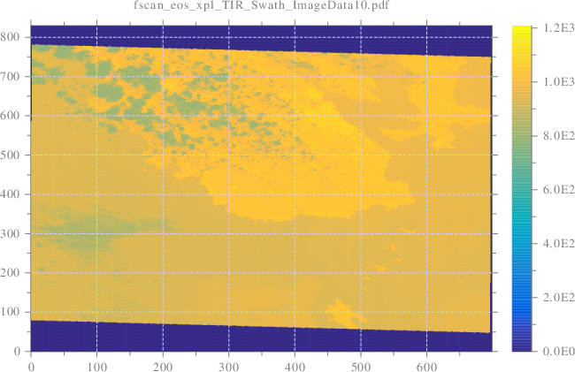
std::string dsname="TIR_Swath", dfname="ImageData10";
int scltype=0/*double*/, dimn;
void **eos=fscan_eos(eospath.c_str(), dsname.c_str(), dfname.c_str(),
scltype, &dimn);
int *crdn=(int*)eos[0], vxn=crdn[0], xi, vyn=crdn[1], yi;
double **val=(double**)eos[1];
double xa=0, xe=(double)vxn-1, ya=0, ye=(double)vyn-1;
scl::string_c imgname=scl::string_c(ƒ)+"_"+dsname+"_"+dfname+".pdf",
imgpath="./srt/"+imgname;
grafmat_dis(imgpath.c_str(), vxn, vyn, val, "grid", "on",
"colormap", "paruline", "subtitlex", imgname.c_str(),
"linespeca", "-a", ∅);
//---------------------------------------------------------------------
//[>LONGITUDE]
//---------------------------------------------------------------------
scl::string_c gfname="Longitude";
eos=fscan_eos(eospath.c_str(), dsname.c_str(), gfname.c_str(),
scltype, &dimn);
crdn=(int*)eos[0]; int xn=crdn[0], yn=crdn[1];
double **lon=(double**)eos[1];
double *x=newtablin(xn, xa, xe), *y=newtablin(yn, ya, ye);
//-----------------------------------------------------------------
//[>RÉGRESSION PLANAIRE]
//-----------------------------------------------------------------
// equation du plan a estimer : x/a+y/b+z/c=1
int tn=xn*yn, ti=0;
double **H=newmat<double>(tn, 3);
for(xi=0;xi<xn;xi++){
for(yi=0;yi<yn;yi++){
H[ti][0]=x[xi]; H[ti][1]=y[yi]; H[ti][2]=lon[xi][yi];
ti++;
}
}
// Pseudo-inverse
double **_H=newmat<double>(3, tn); pinv(tn, 3, H, _H);
double _a=0, _b=0, _c=0; // _H*[1;1;..;1]
for(ti=0;ti<tn;ti++){ _a+=_H[0][ti]; _b+=_H[1][ti]; _c+=_H[2][ti]; }
// Coefficients du plan
double a_lon=1/_a, b_lon=1/_b, c_lon=1/_c;
scltracefc("Plan Lon.: a=%lf, b=%lf, c=%lf\n",
a_lon, b_lon, c_lon);
//-----------------------------------------------------------------
//[<RÉGRESSION PLANAIRE]
//-----------------------------------------------------------------
imgname.clear();
imgname=scl::string_c(ƒ)+"_"+dsname+"_"+gfname+".svg";
imgpath.clear(); imgpath="./srt/"+imgname;
scl::string_c titlex="Plan approché : a="+num_str<double>(a_lon)+
", b="+num_str<double>(b_lon)+", c="+num_str<double>(c_lon);
grafmat_dis(imgpath.c_str(), xn, yn, lon, "grid", "on",
"colormap", "paruline", "subtitlex", imgname.c_str(),
"x", x, "y", y, "titlex", titlex.c_str(),
"linespeca", "-a", ∅);
//---------------------------------------------------------------------
//[<LONGITUDE]
//---------------------------------------------------------------------
//---------------------------------------------------------------------
//[>LATITUDE]
//---------------------------------------------------------------------
gfname.clear(); gfname="Latitude";
eos=fscan_eos(eospath.c_str(), dsname.c_str(), gfname.c_str(),
scltype, &dimn);
crdn=(int*)eos[0]; //xn=crdn[0]; yn=crdn[1];
double **lat=(double**)eos[1];
//double *x=newtablin(xn, xa, xe), *y=newtablin(yn, ya, ye);
//-----------------------------------------------------------------
//[>RÉGRESSION PLANAIRE]
//-----------------------------------------------------------------
// equation du plan a estimer : x/a+y/b+z/c=1
/*int tn=xn*yn,*/ ti=0;
//double **H=newmat<double>(tn, 3),
for(xi=0;xi<xn;xi++){
for(yi=0;yi<yn;yi++){
/*H[ti][0]=x[xi]; H[ti][1]=y[yi];*/ H[ti][2]=lat[xi][yi];
ti++;
}
}
// Pseudo-inverse
/*double **_H=newmat<double>(3, tn);*/ pinv(tn, 3, H, _H);
/*double*/ _a=0; _b=0; _c=0; // _H*[1;1;...;1]
for(ti=0;ti<tn;ti++){ _a+=_H[0][ti]; _b+=_H[1][ti]; _c+=_H[2][ti]; }
// Coefficients du plan
double a_lat=1/_a, b_lat=1/_b, c_lat=1/_c;
scltracefc("Plan Lat.: a=%lf, b=%lf, c=%lf\n",
a_lat, b_lat, c_lat);
//-----------------------------------------------------------------
//[<RÉGRESSION PLANAIRE]
//-----------------------------------------------------------------
imgname.clear();
imgname=scl::string_c(ƒ)+"_"+dsname+"_"+gfname+".svg";
imgpath.clear(); imgpath="./srt/"+imgname;
titlex.clear();
titlex="Plan approché : a="+num_str<double>(a_lat)+
", b="+num_str<double>(b_lat)+", c="+num_str<double>(c_lat);
grafmat_dis(imgpath.c_str(), xn, yn, lat, "grid", "on",
"colormap", "paruline", "subtitlex", imgname.c_str(),
"x", x, "y", y, "titlex", titlex.c_str(),
"linespeca", "-a", ∅);
//---------------------------------------------------------------------
//[<LATITUDE]
//---------------------------------------------------------------------
// Dynamique géodésique (🗺 dislin)
double lona=∞rd, lone=-∞rd, clon, lon_rad;
double lata=∞rd, late=-∞rd, clat, lat_rad;
double cnul=0, cx, cy, cz;
for(xi=0;xi<xn;xi++){
for(yi=0;yi<yn;yi++){
clon=lon[xi][yi]; lon_rad=clon/180*π;
clat=lat[xi][yi]; lat_rad=clat/180*π;
// Passage coordonnées géocentriques/sphériques (🗺 hdf-eos)
// vers coordonnées géodésiques (🗺 dislin)
llac_xyze(1, &lon_rad, &lat_rad, &cnul, &cx, &cy, &cz);
xyze_llg(1, &cx, &cy, &cz, &clon, &clat);
clon=clon/π*180; clat=clat/π*180;
if(lona>clon){ lona=clon; } if(lone<clon){ lone=clon; }
if(lata>clat){ lata=clat; } if(late<clat){ late=clat; }
}
}
// Surface et longueur d'un pixel rectifié
double sx=(lone-lona)*(late-lata)/(((double)vxn)*((double)vyn)),
lx=√(sx);
int stlonn=(int)round((lone-lona)/lx), stloni;
double *stlon=newtablin(stlonn, lona, lone);
int stlatn=(int)round((late-lata)/lx), stlati;
double *stlat=newtablin(stlatn, lata, late);
int stn = stlonn*stlatn, sti;
scltracefc("stn=lonn*latn=%d*%d=%d\n", stlonn, stlatn, stn);
double *stx=new double[stn], *sty=new double[stn];
int *stin = new int[stn];
for (stloni=0;stloni<stlonn;stloni++){
clon=stlon[stloni]; lon_rad=clon/180*π;
for (stlati=0;stlati<stlatn;stlati++){
clat=stlat[stlati]; lat_rad=clat/180*π;
// Passage géodésique (🗺 dislin) vers
// géocentrique (🗺 hdf-eos)
llg_llc(1, &lon_rad, &lat_rad, &clon, &clat);
clon=clon/π*180; clat=clat/π*180;
sti = stlati + stloni*stlatn;
// Résolution du sytème
// x/a_lon + y/b_lon + lon/c_lon = 1
// x/a_lat + y/b_lat + lat/c_lat = 1
stx[sti]=(b_lon-b_lat-(clon*b_lon/c_lon-clat*b_lat/c_lat))/
(b_lon/a_lon-b_lat/a_lat);
sty[sti]=(a_lon-a_lat-(clon*a_lon/c_lon-clat*a_lat/c_lat))/
(a_lon/b_lon-a_lat/b_lat);
/*scltracefc("stx[%d]=%lf, sty[%d]=%lf\n",
sti, stx[sti], sti, sty[sti]);*/ //🔬
}
}
//---------------------------------------------------------------------
// Interpolation bilinéaire
double *stval = new double[stn];
tic();
interpmat(vxn, vyn, val, ∅, xa, xe, ya, ye,
stn,stx,sty,stval,∅,∅,stin);
scltracefc("Duree de l'interpolation bilineaire=%lf [s]\n",
tac()/103);
double **vmat=tab_mat<double>(stlonn, stlatn, stval, 2);
int **inmat = tab_mat<int>(stlonn, stlatn, stin, 2);
imgname.clear();
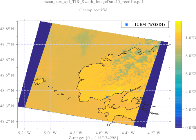
imgname=std::string(ƒ)+"_"+dsname+"_"+dfname+"_rectifie.pdf",
imgpath.clear(); imgpath="./srt/"+imgname;
double iuemlon_deg=-4.562854, iuemlat_deg=48.358529; // WGS84
tic();
grafmat_dis(imgpath.c_str(), stlonn, stlatn, vmat, "x", stlon, "y", stlat,
"instatus", inmat, "curve", 1, &iuemlon_deg, &iuemlat_deg,
"linespec", "l*", "subtitle", "Champ rectifié",
"title", imgname.c_str(), "xlabel", "Z-range: [<azrange>]",
"geographic", "flat", "colormap", "paruline",
"legend", "IUEM (WGS84)", "legcorn", "ura",
"linespeca", "-a", ∅);
// Libr. memoire
deletemat<double>(stlonn, &vmat);
free(stlon); stlon=∅; free(stlat); stlat=∅;
deletemat<int>(stlonn, &inmat);
scltracefe(§, ƒ, ∅);
return 0;
}
/* ƒ décorée par  le 21-03-2025 21:05:02 */
Sortie


[>..\xpl\src\sclhdf.eos.xpl.cpp.fscan_eos_xpl]
scl-25.03 (gwin64) : 21-03-2025 21:05:02
< hdf-eos-2.19
>>>>>>>>>>>>>>>>>>>>>>>>>>>>>>>>
[>HDF-EOS FILE INFORMATIONS]
>>>>>>>>>>>>>>>>>>>>>>>>>>>>>>>>
OS benchmark:
- sizeof(double)=8
- sizeof(float) =4
- sizeof(int) =4
- sizeof(long) =4
filepath : './don/hdf/AST_L1B_003_09212000113746_09232003073119.hdf'
- version : 'HDFEOS_V2.8'
- type : SWATH
- 'VNIR_Swath'
- Dimension map: GeoTrack/ImageLine
- offset : 0
- increment: 420
- Dimension map: GeoXtrack/ImagePixel
- offset : 0
- increment: 498
- Dimension map: GeoTrack/ImageLine3B
- offset : 400
- increment: 420
- Geo field: 'Latitude'
- Type: FLOAT64 (8 [byte])
- Size: [11][11]
- Geo field: 'Longitude'
- Type: FLOAT64 (8 [byte])
- Size: [11][11]
- Data field: 'ImageData1'
- Type: UINT8 (1 [byte])
- Size: [4200][4980]
- Data field: 'ImageData2'
- Type: UINT8 (1 [byte])
- Size: [4200][4980]
- Data field: 'ImageData3N'
- Type: UINT8 (1 [byte])
- Size: [4200][4980]
- Data field: 'ImageData3B'
- Type: UINT8 (1 [byte])
- Size: [4600][4980]
- 'SWIR_Swath'
- Dimension map: GeoTrack/ImageLine
- offset : 0
- increment: 210
- Dimension map: GeoXtrack/ImagePixel
- offset : 0
- increment: 249
- Geo field: 'Latitude'
- Type: FLOAT64 (8 [byte])
- Size: [11][11]
- Geo field: 'Longitude'
- Type: FLOAT64 (8 [byte])
- Size: [11][11]
- Data field: 'ImageData4'
- Type: UINT8 (1 [byte])
- Size: [2100][2490]
- Data field: 'ImageData5'
- Type: UINT8 (1 [byte])
- Size: [2100][2490]
- Data field: 'ImageData6'
- Type: UINT8 (1 [byte])
- Size: [2100][2490]
- Data field: 'ImageData7'
- Type: UINT8 (1 [byte])
- Size: [2100][2490]
- Data field: 'ImageData8'
- Type: UINT8 (1 [byte])
- Size: [2100][2490]
- Data field: 'ImageData9'
- Type: UINT8 (1 [byte])
- Size: [2100][2490]
- 'TIR_Swath'
- Dimension map: GeoTrack/ImageLine
- offset : 0
- increment: 70
- Dimension map: GeoXtrack/ImagePixel
- offset : 0
- increment: 83
- Geo field: 'Latitude'
- Type: FLOAT64 (8 [byte])
- Size: [11][11]
- Geo field: 'Longitude'
- Type: FLOAT64 (8 [byte])
- Size: [11][11]
- Data field: 'ImageData10'
- Type: UINT16 (2 [byte])
- Size: [700][830]
- Data field: 'ImageData11'
- Type: UINT16 (2 [byte])
- Size: [700][830]
- Data field: 'ImageData12'
- Type: UINT16 (2 [byte])
- Size: [700][830]
- Data field: 'ImageData13'
- Type: UINT16 (2 [byte])
- Size: [700][830]
- Data field: 'ImageData14'
- Type: UINT16 (2 [byte])
- Size: [700][830]
- type : GRID [not available]
- type : POINT [not available]
<<<<<<<<<<<<<<<<<<<<<<<<<<<<<<<<
[<HDF-EOS FILE INFORMATIONS]
<<<<<<<<<<<<<<<<<<<<<<<<<<<<<<<<
<<<<<<<<<<<<<<<<<<<<<<<<<<<<<<<<<<<<<<<<<<<<<<<<<<<<<<<<<<<<<<<<<<
<< END OF DISLIN / VERSION 11.3.2 <<
<< Date : 21.03.2025 Time : 21:05:03 Pageformat: DA4L <<
<< Vectors : 1301 Warnings: 0 Fileformat: PDF <<
<< Metafile: ./srt/fscan_eos_xpl_TIR_Swath_ImageData10.pdf <<
<<<<<<<<<<<<<<<<<<<<<<<<<<<<<<<<<<<<<<<<<<<<<<<<<<<<<<<<<<<<<<<<<<
Plan Lon.: a=-20173.501061, b=4254.037309, c=-5.077153
<<<<<<<<<<<<<<<<<<<<<<<<<<<<<<<<<<<<<<<<<<<<<<<<<<<<<<<<<<<<<<<<<<
<< END OF DISLIN / VERSION 11.3.2 <<
<< Date : 21.03.2025 Time : 21:05:03 Pageformat: DA4L <<
<< Vectors : 1300 Warnings: 0 Fileformat: SVG <<
<< Metafile: ./srt/fscan_eos_xpl_TIR_Swath_Longitude.svg <<
<<<<<<<<<<<<<<<<<<<<<<<<<<<<<<<<<<<<<<<<<<<<<<<<<<<<<<<<<<<<<<<<<<
Plan Lat.: a=61297.404633, b=290797.808838, c=48.661846
<<<<<<<<<<<<<<<<<<<<<<<<<<<<<<<<<<<<<<<<<<<<<<<<<<<<<<<<<<<<<<<<<<
<< END OF DISLIN / VERSION 11.3.2 <<
<< Date : 21.03.2025 Time : 21:05:03 Pageformat: DA4L <<
<< Vectors : 1302 Warnings: 0 Fileformat: SVG <<
<< Metafile: ./srt/fscan_eos_xpl_TIR_Swath_Latitude.svg <<
<<<<<<<<<<<<<<<<<<<<<<<<<<<<<<<<<<<<<<<<<<<<<<<<<<<<<<<<<<<<<<<<<<
stn=lonn*latn=988*588=580944
Duree de l'interpolation bilineaire=0.024125 [s]
<<<<<<<<<<<<<<<<<<<<<<<<<<<<<<<<<<<<<<<<<<<<<<<<<<<<<<<<<<<<<<<<<<
<< END OF DISLIN / VERSION 11.3.2 <<
<< Date : 21.03.2025 Time : 21:05:04 Pageformat: DA4L <<
<< Vectors : 8597 Warnings: 0 Fileformat: PDF <<
<< Metafile: ./srt/fscan_eos_xpl_TIR_Swath_ImageData10_rectif <<
<<<<<<<<<<<<<<<<<<<<<<<<<<<<<<<<<<<<<<<<<<<<<<<<<<<<<<<<<<<<<<<<<<
[<..\xpl\src\sclhdf.eos.xpl.cpp.fscan_eos_xpl]